
Drone Services
Drone Surveys and Mapping
Who uses Drone Surveys
- Golf Course Architect’s
- Estate Agents
- Agricultural Agronomists’
- Construction Professionals
- Environmental Scientists

What it covers
Comprehensive Drone Surveys and Maps
We ensure data accuracy and efficiency, offering actionable insights for your success. Discover the Vantage Imagery difference—contact us today to see how our services can benefit your project. The drone mapping process can produce a 2D/3D georeferenced map or a point cloud. This is fully interactive, measurements can easily be made directly onto the map, measuring distance, area and gradient
Features
- 2D/3D Georeferenced Maps
- Topographical Surveys
- Irrigation System Mapping
- Digital Surface Models (DSM)
- Plant Health Monitoring
Georeferrenced Maps
Drone Survey 2D/3D Mapping


How it Works
Streamlined Drone Surveys for Precision Results
Initial discussion to understand your project
Detailed project planning, logistics and Analysis
Conduct aerial surveys using state-of-the-art Drones
Provide comprehensive reports and visuals
Drone Survey Equipment

This is one of 2 we use in RTK (Real Time Kinematics) or using NTRIP services. To collect GCP’s (ground control points) and check points to add to the maps accuracy.
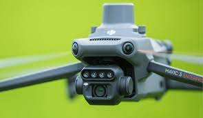
The latest technology from DJI Mavic 3 Multispectral drone, equipped with RTK and a 20 megapixel mechanical shutter main camera. It also has four 5mp multispectral cameras making this the ultimate survey drone.
Vantage Imagery Ltd is NOT a survey company and it does not claim to be accredited surveyors or geomatics specialists.
Provided geospatial products would typically fall within the potential accuracy range as indicated within the 'RICS Professional Guidance Note - Measured Surveys of Land, Buildings and Utilities (Bands D to E)' and, therefore, must not be further used beyond its tasked-for requirements and /or to support other projects that would require greater degrees of accuracies."
Our geospatial products SHOULD NOT be independently used to authenticate measurements of any kind and be used in any legally-binding documentation UNLESS they have been ortho-rectified and are accompanied with additional and authenticated positional geodetic information that has been provided by a trained/accredited party accompanied by accuracy statements and which would compliment other accurate and project-supporting geospatial-related data.
