
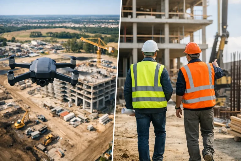
If you have ever stood on a wet site trying to understand what has really changed since last week, the debate around aerial progress photos vs site walks stops being theoretical very quickly. What matters is simple – can you see enough, early enough, and clearly enough to make the right decision without wasting time, money or labour?
For construction teams, estate managers and golf course professionals managing project works, both methods have a place. A site walk gives close-up, ground-level detail. Aerial progress photography gives a wider operational view that a person on foot simply cannot match. The better question is not which one is universally best, but which one gives the most useful intelligence for the decision in front of you.
Aerial progress photos vs site walks – what is the real difference?
A site walk is direct, familiar and immediate. You walk the area, inspect works in person, speak to contractors, spot practical issues and make judgements based on what you can physically see from ground level. That can be very effective for checking finish quality, access problems, safety housekeeping or the condition of a specific asset.
Aerial progress photos work differently. Instead of relying on a person moving through the site and seeing only from the ground, a drone captures a consistent overhead and oblique record of the entire area. That creates a visual timeline of change. On a construction site, that could mean tracking earthworks, drainage runs, material storage, access routes or programme movement across multiple zones. On a golf course project, it could mean monitoring bunker renovation, irrigation installation, reshaping, path works or grow-in progress with much clearer spatial context.
The main difference is perspective. Site walks show detail at eye level. Aerial progress imagery shows relationships between features, work areas and stages of progress. When timing, sequencing and site-wide visibility matter, that broader perspective becomes a commercial advantage.
Where site walks still matter
It would be a mistake to dismiss site walks as outdated. They remain essential because many decisions still require human presence on the ground. If you need to inspect workmanship on a retaining edge, review a snagging issue, discuss a trench depth with an operative or verify whether an area is safely accessible, being there matters.
Site walks are also useful when the issue is tactile or highly localised. Standing on a newly shaped tee or around a compound entrance tells you things that imagery alone may not. Surface firmness, finish quality, minor defects and live coordination between trades are often better assessed in person.
There is also a behavioural benefit. Regular walks keep managers visible and engaged. They create accountability and support quicker conversations. For some projects, that daily physical presence is part of effective leadership.
The limitation is that site walks are selective by nature. Even experienced managers can only cover so much ground, and what they record depends heavily on where they walked, what they noticed and how consistently they documented it.
Why aerial progress photos are gaining ground
Aerial progress photography has become far more valuable as clients expect better reporting, clearer evidence and less ambiguity. A drone flight can capture the whole site in a repeatable format, from the same positions and heights at regular intervals. That consistency is difficult to achieve with photographs taken ad hoc during a walk.
The first major benefit is visibility. Large or complex sites rarely make sense from the ground. An overhead image immediately shows how works are moving across the whole area. You can assess haul roads, stockpiles, drainage corridors, stripped sections, completed zones and inactive areas in one view.
The second benefit is communication. Progress is much easier to explain to stakeholders when they can see the site clearly. Whether reporting to a client, consultant, committee or senior management team, aerial imagery reduces the need for interpretation. It creates a shared visual reference point.
The third is record keeping. A properly captured sequence of aerial images becomes an objective history of the job. If questions arise around delays, sequencing, access constraints or pre-existing conditions, that visual record can be extremely useful.
For clients who need more than simple photographs, aerial progress capture can also sit alongside mapping outputs, measured models and annotated site plans. That is where a specialist provider adds value. The imagery is not just attractive – it becomes operationally useful.
Aerial progress photos vs site walks for decision-making
When the goal is better decision-making, aerial progress photos often outperform site walks in three areas.
First, they improve spatial understanding. This is especially important where multiple work fronts are active at once. Aerial views show whether operations are flowing logically, whether access routes are being maintained and whether temporary arrangements are starting to constrain the next phase.
Second, they support earlier intervention. Ground-based issues are often spotted only when someone reaches that part of the site. Aerial capture can reveal developing problems sooner, such as water holding in a newly formed area, material creep into protected zones or unexpected disruption to adjacent surfaces.
Third, they improve consistency in reporting. One manager’s site walk notes may differ from another’s. A repeatable aerial dataset gives everyone the same baseline.
That said, site walks remain stronger when the decision depends on close physical inspection. If you are checking finish standards, compliance with a specification at detail level or practical buildability on the ground, aerial imagery should support the visit rather than replace it.
The trade-off between speed and depth
A site walk can be done immediately, without planning a flight, and it often answers a narrow question quickly. If the issue is isolated and urgent, that speed is useful.
Aerial progress photos, however, can cover far more ground in less time and with greater consistency. On expansive sites, that efficiency matters. Instead of spending hours walking every zone, decision-makers can review a full visual update and then target their site visit where it is genuinely needed.
This is where the best operational model usually emerges. Use aerial imagery to identify where attention is required, then use site walks for validation, inspection and action. That reduces wasted time and focuses people where they add most value.
Reporting value for commercial clients
For commercially driven projects, the strongest case for aerial progress photography is often not the flight itself but the reporting value it creates afterwards. Senior stakeholders rarely want a verbal account that depends on memory and loose phone photos. They want clear evidence of progress, constraints and outstanding work.
Aerial imagery helps turn site updates into something more credible and more useful. It supports progress meetings, contractor reviews, programme monitoring and investor or client reporting. It also helps non-technical stakeholders understand the job without needing to visit the site themselves.
For golf course projects, this can be particularly valuable. Committees, owners and consultants often need to understand how a scheme is affecting the wider course, not just one isolated work area. Aerial progress photos make it easier to show how construction activity connects to playability, routing, drainage, irrigation installation and reinstatement.
When each method is the better choice
If your site is small, the issue is highly specific and the priority is close inspection, a site walk may be enough. If the project is spread out, changing quickly or difficult to understand from ground level, aerial progress photos are likely to provide better oversight.
If reporting to external stakeholders matters, aerial imagery usually adds more value. If daily supervision of workmanship is the main concern, site walks remain indispensable. If the goal is to create a reliable time-stamped visual record, aerial capture is clearly stronger.
In practice, the most effective clients rarely choose one or the other in absolute terms. They use each for what it does best. Aerial photography provides the strategic view. Site walks provide the practical, close-range inspection needed to act on what the imagery reveals.
That is why specialist delivery matters. When aerial capture is planned around operational questions rather than treated as a simple photo exercise, it becomes a management tool. For firms such as Vantage Imagery Limited, the value lies in producing precise, repeatable visual data that supports decisions on the ground.
If you are deciding between aerial progress photos vs site walks, start with the outcome you need rather than the method you already know. The right choice is the one that shows the truth of the site clearly enough for you to act with confidence.
