
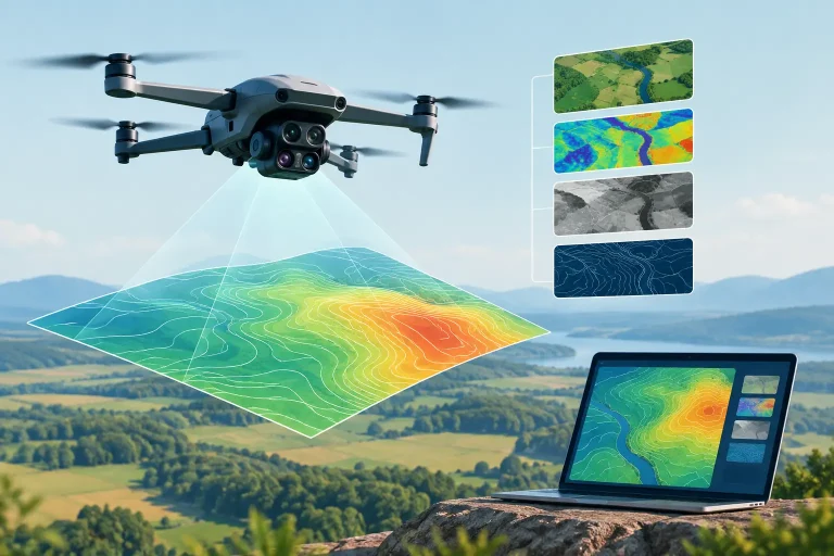
A golf course survey is only valuable when the resulting files can be used by the people making decisions. Drone data formats determine whether imagery becomes a practical irrigation plan, a drainage investigation, a contractor briefing or simply a large file that never leaves the desktop. Selecting the right outputs at the start helps turn centimetre-accurate capture into clear action on the ground.
For course managers, greenkeepers, architects and irrigation specialists, the question is not which format is most technical. It is which format fits the task, the software already in use and the level of detail required. A high-resolution orthomosaic may be ideal for reviewing bunker edges, while a CAD drawing or point cloud is more appropriate for design work and earthworks calculations.
Why drone data formats matter in surveying
A drone can capture thousands of overlapping images during a single flight. Photogrammetry software processes those images into mapped products, each designed to answer a different operational question. The original photographs are not, by themselves, a survey deliverable. They need positional information, processing and quality control before they become a dependable mapping asset.
The format affects how data is viewed, measured, shared and integrated. A JPEG is easy to open and useful for a board report, but it is not normally suitable for measuring a proposed drainage route. A georeferenced TIFF can be loaded into GIS or CAD software at the correct coordinates, allowing designers and contractors to work from a consistent spatial reference.
Getting this right also prevents costly rework. If a consultant needs contours in DWG format but receives a flat image, the team may need to request further processing. A properly scoped survey provides the visual and technical outputs required for the project from the outset.
The drone data formats most useful on a golf course
Orthomosaic imagery: GeoTIFF and JPEG
An orthomosaic is a corrected, stitched aerial image. Unlike a standard aerial photograph, it is adjusted for perspective and terrain so distances and positions can be measured accurately when appropriate survey control has been used. It provides an up-to-date, high-detail view of the entire course, from tees and greens to paths, water features and maintenance compounds.
GeoTIFF is usually the preferred working format for professional mapping. It retains the image alongside coordinate information, making it suitable for GIS platforms, CAD workflows and specialist irrigation or estate-management systems. It is particularly effective for asset inventories, condition reviews and overlaying proposed works against existing features.
A JPEG or PDF map is often supplied as a convenient viewing version. These are useful for sharing with committees, contractors and staff who do not use geospatial software. They should be treated as communication products rather than the primary technical dataset unless georeferencing and scale requirements have been confirmed.
Surface models: DSM and DTM
Elevation data is essential when water movement, earthworks or site levels are under review. A Digital Surface Model, or DSM, represents the height of everything visible from above. This can include trees, buildings, machinery and vegetation as well as the ground surface.
A Digital Terrain Model, or DTM, aims to represent bare-earth levels by filtering out surface features. On an open golf course, it can support drainage assessments, contour generation, cut-and-fill planning and strategic course design. However, dense canopy, long grass and complex vegetation can limit what photogrammetry can see at ground level. Where ground beneath vegetation is critical, a different capture method such as LiDAR may be the more appropriate specification.
Both models are commonly delivered as GeoTIFF files. The distinction matters: using a DSM to assess subtle falls across a fairway can produce misleading results if trees or structures influence the surface. The right model depends on the decision being made.
Point clouds: LAS and LAZ
A point cloud is a large collection of three-dimensional points, each with measured coordinates and elevation. In drone photogrammetry, these points are generated from the overlap between images. They can show terrain, structures, bunkers, retaining walls and other site features in far greater depth than a two-dimensional map.
LAS is a widely recognised point-cloud format, while LAZ is its compressed equivalent. LAZ files are smaller and easier to transfer, which is useful for large sites, without changing the underlying data. Surveyors, designers and engineers can use point clouds within compatible CAD, modelling and analysis software.
Point clouds are powerful, but they are not always necessary. For a routine course overview, they can be more data than the operational team needs. They become especially valuable for redevelopment, detailed topographical work, stockpile measurement, building assessments and complex construction tracking.
CAD and GIS vector files: DWG, DXF, SHP and GeoPackage
Raster imagery shows what the site looks like. Vector data describes individual mapped features as lines, points and polygons. A drainage run can be a line, a valve can be a point, and each green or bunker can be a polygon with attributes attached to it.
DWG and DXF formats are common in CAD workflows. They are useful where architects, engineers or contractors need survey information in a drawing environment. Contours, breaklines, spot levels, boundaries and utility features can be supplied as editable layers, allowing proposed designs to be developed over accurate existing conditions.
Shapefiles remain common in GIS, although they comprise several supporting files and can become awkward to manage. GeoPackage is a modern alternative that stores multiple layers and their attributes in a single file. For irrigation mapping and long-term asset management, this can be a practical choice because the data is structured, portable and easier to maintain.
Multispectral outputs for turf health
Multispectral surveys capture information beyond visible light. The processed result may include vegetation indices, such as NDVI, that help identify variation in plant vigour across greens, tees, fairways and rough. These outputs are often delivered as georeferenced raster files, supported by colour-coded map PDFs for straightforward review.
The colour scale should never be treated as a diagnosis on its own. A low-vigour area may relate to moisture stress, compaction, disease pressure, nutrient availability, shade or recent maintenance activity. The real value comes from using the map to target on-the-ground inspection and compare patterns over time.
Accuracy is not built into the file extension
A GeoTIFF, DWG or LAS file is not automatically survey-grade merely because of its format. Accuracy depends on flight planning, camera calibration, ground control, RTK or PPK positioning, processing methodology and independent checks. The coordinate reference system also needs to be specified correctly, particularly where drone data will sit alongside an existing topographical survey, utility record or design model.
For UK projects, clients should confirm the required coordinate system and vertical datum before the flight. This is essential when levels are being compared with previous surveys or used for drainage falls and construction setting-out. A clearly stated accuracy report and survey methodology provide far more assurance than a file name alone.
Resolution matters too. A very high-resolution image may look impressive but create large, slow files. For strategic whole-course mapping, a sensible ground sampling distance can offer excellent usability without unnecessary data volume. For close inspection of a roof, bunker face or drainage outfall, a tighter specification may be justified.
Specify the output around the decision
Before commissioning a survey, define what will happen after the data is delivered. If the aim is to locate heads, valves and pipe routes for an irrigation upgrade, request a georeferenced orthomosaic plus editable GIS or CAD layers. If a course architect is considering remodelling, ask for a DTM, contours, spot levels and compatible design files. If the priority is communicating a programme of work to a committee, a clear annotated PDF may be just as valuable as the technical source data.
It is also worth agreeing who needs access. Greenkeeping teams may need simple visual maps on a tablet, while consultants require full-resolution data and coordinate information. Providing both viewing files and professional working files avoids forcing every user into the same software or skill level.
At Vantage Imagery, the objective is not to provide a folder of impressive files. It is to supply drone survey outputs that support better maintenance, investment and design decisions. The most effective dataset is the one your team can understand, share and act on when the next question arises on the course.