 Skip to main content
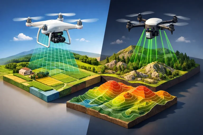
A fair comparison of drone mapping versus LiDAR starts with the decision you need to make on the ground. A course manager planning drainage works, an architect reshaping a hole, or a contractor pricing earthworks does not simply need an impressive aerial image. They need dependable levels, clear asset visibility and data that can be used with confidence.
Both methods can produce highly valuable survey information at speed. The better option depends on whether you need a detailed surface model, a view through vegetation, visual condition information, or a combination of all three.
Drone Mapping Versus LiDAR: The Core Difference
In most commercial survey conversations, drone mapping means photogrammetry. A drone captures hundreds or thousands of overlapping high-resolution photographs, then specialist software identifies matching points across those images to construct a measurable 3D model. From this, survey teams can create orthomosaic maps, contours, digital surface models, point clouds and volume calculations.
LiDAR, short for Light Detection and Ranging, uses laser pulses rather than photographs. The sensor measures the time taken for each pulse to return after striking a surface. This creates a dense cloud of measured points, often with multiple returns from a single pulse. That ability is the defining advantage: some pulses can pass through gaps in tree canopy or vegetation to reach the ground beneath.
The two technologies are not direct rivals in every respect. Drone photogrammetry is usually stronger for sharp, colour-rich visual mapping. LiDAR is often stronger where the true ground surface is obscured. In many high-value projects, the most useful answer is to combine LiDAR terrain data with drone imagery.
What Drone Photogrammetry Does Best
For open sites, photogrammetry delivers exceptional detail and visual clarity. With well-planned flights, accurate ground control or RTK positioning, and rigorous processing, it can produce centimetre-accurate mapping suitable for a wide range of golf, estate and construction applications.
A current aerial orthomosaic is particularly useful because it is easy for non-survey specialists to understand. It shows fairways, bunkers, paths, greens, water features, buildings, tree lines and exposed drainage features in their real-world context. That makes it a practical working layer for course management, planning discussions and contractor briefings.
On a golf course, photogrammetry is highly effective for measuring bunker areas, mapping cart paths, calculating stockpile volumes, recording construction progress and establishing detailed as-built information. It can also support irrigation and drainage mapping when visible features, valve locations and existing plans are brought together into one coordinated output.
Photogrammetry has another important advantage: it captures colour and texture. That makes it valuable for promotional aerial imagery, visual inspections and condition monitoring. When multispectral sensors are used, it can reveal patterns in turf vigour that are not obvious from ground level, helping greenkeeping teams investigate irrigation performance, compaction, nutrient availability or emerging disease pressure.
Its limitation is straightforward. A camera cannot reliably map what it cannot see. Thick woodland, dense scrub, long rough and overhanging canopy may be represented as the top of the vegetation rather than the terrain below it.
Where LiDAR Adds Greater Value
LiDAR earns its place when ground visibility is the primary challenge. Its laser pulses can generate terrain data beneath partial canopy, making it particularly valuable for wooded land, embankments, drainage corridors, watercourses and sites with dense vegetation.
For a golf course with mature woodland, LiDAR can help reveal subtle terrain changes that conventional imagery may conceal. Historic ditches, shallow swales, old drainage routes, banks and ground depressions can become visible in a classified bare-earth model. This information can be valuable before drainage design, course redevelopment, ecological planning or tree-management work.
LiDAR also performs well in low-texture environments where photogrammetry can struggle to find matching image detail. Uniform grass, shadowed areas and certain reflective or repetitive surfaces may require additional care during photographic processing. LiDAR measures distance directly, so it is less dependent on visual texture.
That does not mean LiDAR automatically produces a perfect ground model. Dense evergreen cover, very thick bracken or closely packed vegetation can still prevent sufficient pulses reaching the surface. The survey specification, flight height, sensor capability, point density and classification process all affect the final result. Survey-grade output relies on experienced acquisition and quality assurance, not simply hiring a sensor.
Accuracy Is More Than a Headline Figure
Both drone photogrammetry and drone-borne LiDAR can achieve centimetre-level accuracy when deployed correctly. However, headline accuracy figures should be treated carefully. Absolute accuracy, relative accuracy, point density, resolution and confidence in the final surface are related but different measures.
A photogrammetry project may create an exceptionally detailed model of visible ground, but vegetation can compromise its representation of terrain. A LiDAR survey may identify ground beneath canopy, but its point cloud is not usually as visually rich as an orthomosaic. The right question is not which method is “more accurate” in general. It is which method measures the feature that matters to your project.
For example, if a contractor needs cut-and-fill volumes across an open construction site, photogrammetry can be a highly efficient and accurate solution. If a consultant needs to understand runoff routes through wooded ground surrounding a golf hole, LiDAR may provide the more reliable terrain model.
Control remains essential. RTK and PPK drone workflows improve positional accuracy, while well-distributed ground control points provide an independent check on survey quality. A professional deliverable should include appropriate validation, coordinate information and a clear understanding of the tolerances required for the intended use.
Cost, Speed and Deliverables
Photogrammetry is usually the more cost-effective choice for broad-area mapping, especially where the site is open and visual detail is important. It can collect a substantial amount of information in a short flight window and generate outputs that are immediately useful to managers, designers and contractors.
LiDAR sensors are more specialised, and projects often carry a higher acquisition and processing cost. That additional investment can be justified quickly where vegetation would otherwise require extensive ground survey, where access is difficult, or where inaccurate terrain data could lead to poor drainage decisions and costly remedial work.
The expected deliverables should guide the choice. An orthomosaic, textured 3D model, high-resolution surface model and annotated asset plan point towards photogrammetry. A classified point cloud, bare-earth digital terrain model and contours beneath partial canopy point towards LiDAR. If you need terrain intelligence and clear visual communication, a combined survey is often the strongest option.
A practical specification for golf and land management
Before commissioning either service, define the operational question. Is the priority to plan drainage? Map irrigation assets? Measure earthworks? Review tree encroachment? Create a base plan for an architect? Or monitor turf health over time?
It is also worth agreeing the coordinate system, required contour interval, accuracy tolerance, file formats and whether the output needs to integrate with existing CAD, GIS or irrigation-control workflows. This avoids receiving technically impressive data that is difficult to apply on site.
For golf facilities, survey timing matters as much as technology. Leaf-off conditions can improve terrain visibility in wooded areas. Dry ground may assist interpretation of drainage patterns, while repeat surveys taken at the same time of year can make construction or turf-condition comparisons more meaningful.
Choosing the Right Survey Method
Choose drone photogrammetry when the site is predominantly open and you need detailed, colour-accurate mapping with strong visual context. It is well suited to course mapping, asset inventories, roof inspections, progress reporting, earthwork measurement and promotional imagery.
Choose LiDAR when woodland, scrub or complex vegetation hides the ground you need to understand. It is particularly effective for terrain modelling, drainage investigations, woodland-edge development and larger estate surveys where bare-earth data will influence design decisions.
Choose both when decisions depend on seeing the site clearly and measuring the terrain beneath it. A colour orthomosaic can help teams communicate the plan, while LiDAR-derived terrain data provides the technical confidence behind it. For complex schemes, that combination reduces assumptions before work begins.
The best survey is the one that turns aerial data into an operational advantage. Whether the need is a clean map of open fairways or a dependable terrain model beneath mature trees, the specification should begin with the maintenance, design or construction decision it needs to support.
