 Skip to main content
A drainage scheme can fail on paper long before work starts on the ground. The cause may be a subtle fall hidden beneath rough, long grass, a missing culvert, or levels collected without sufficient detail around a green complex. That is why the question of drone photogrammetry vs lidar is not simply about choosing a sensor. It is about specifying data that supports confident decisions on design, maintenance, budgets and delivery.
For golf courses, estates and construction sites, both technologies can produce highly accurate survey outputs. Their strengths are different, however. Photogrammetry excels at detailed visual mapping and surface models where the ground is visible. LiDAR is the stronger option where vegetation conceals the terrain or where a cleaner representation of the bare earth is required.
What drone photogrammetry measures
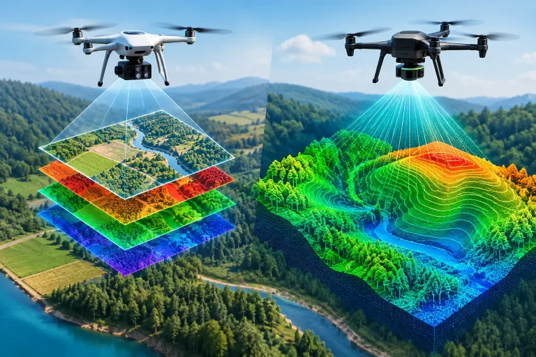
Drone photogrammetry creates a map from hundreds or thousands of overlapping aerial photographs. Specialist processing software identifies common points between images and reconstructs the site in three dimensions. With a planned flight, suitable ground control or RTK positioning, and professional processing, this can provide centimetre-accurate mapping over substantial areas.
The result is exceptionally information-rich. A photogrammetry survey can produce a high-resolution orthomosaic, colourised point cloud, digital surface model and contour plan. Every visible feature is represented in true photographic detail: bunkers, paths, tee edges, irrigation boxes, exposed drainage runs, buildings, stockpiles and vegetation.
That visual clarity is a major operational advantage. A course manager can use an orthomosaic to discuss bunker renovation areas with a contractor, verify the location of visible assets, or communicate a proposed project to a committee. For earthworks, the same dataset can support cut-and-fill calculations and progress tracking, provided the surface is visible.
Photogrammetry does have a critical limitation: it records what the camera can see. Dense canopy, scrub, bracken and long grass may obscure the terrain below. Software can classify some vegetation from a point cloud, but it cannot reliably recover ground levels that were never visible in the source images.
What drone LiDAR measures
LiDAR stands for Light Detection and Ranging. A laser scanner emits rapid pulses towards the ground and measures the time taken for each pulse to return. Each return becomes a point with a three-dimensional coordinate. Modern drone LiDAR systems collect a dense point cloud while the aircraft follows a carefully planned survey route.
Unlike a conventional camera, a LiDAR sensor can obtain returns through gaps in vegetation. Some laser pulses strike leaves or branches, while others reach the ground. After classification and quality control, the survey team can isolate ground points and create a digital terrain model that represents the underlying landform more effectively than image-based mapping in vegetated areas.
This makes LiDAR especially valuable for wooded course boundaries, overgrown ditches, embankments, watercourse corridors and development sites with rough vegetation. It can expose subtle channels, historic earthworks, drainage routes and changes in grade that may affect water movement or construction design.
LiDAR is not a substitute for imagery in every situation. Its raw output is a cloud of measured points rather than a natural-colour photograph. Many projects benefit from LiDAR data paired with high-quality aerial imagery, giving teams both reliable ground levels and a clear visual reference.
Drone photogrammetry vs LiDAR: the practical differences
The decision should be based on the required output, site conditions and the decision the data must support. Neither method is automatically more accurate in all circumstances. Accuracy depends on sensor quality, flight planning, positioning, control, calibration, terrain, vegetation and independent checks.
| Requirement | Photogrammetry | LiDAR | |—|—|—| | Detailed aerial visual map | Excellent | Limited without accompanying imagery | | Bare-earth terrain below vegetation | Limited | Excellent where laser returns reach the ground | | Visible hard surfaces and earthworks | Excellent | Very good | | Fine colour detail for asset identification | Excellent | Usually requires imagery | | Point cloud capture in wooded areas | Variable | Strong | | Typical project cost | Often lower | Usually higher due to specialist equipment and processing |
For an open fairway, driving range or construction platform, photogrammetry may provide all the survey detail required at excellent value. On an overgrown boundary where levels are needed for a drainage design, LiDAR can prevent a false reading of the vegetation canopy being mistaken for terrain.
The distinction matters around water management. A photogrammetric surface model may show the top of rough grass rather than the ground beneath it. If this surface is used uncritically to assess drainage falls, the resulting design may be based on the wrong elevations. A classified LiDAR terrain model can give designers a much more dependable starting point in those conditions.
Choosing the right approach for golf course mapping
Golf courses rarely present one uniform survey environment. They combine short turf, mature woodland, bunkers, ponds, dense planting, buildings, cart paths and changing levels around greens and tees. A successful specification therefore considers each survey zone rather than applying one technology across the entire property.
Photogrammetry is often the first choice for an up-to-date course-wide basemap. It delivers the visual information needed to map visible irrigation components, paths, bunkers, greens, tees and maintenance infrastructure. The imagery can be integrated into operational mapping systems and used as a common reference by greenkeeping teams, consultants and contractors.
LiDAR becomes more compelling where strategic terrain information is obscured. Consider a club investigating repeated flooding near a wooded ditch, planning a new hole through mature trees, or assessing runoff from an undeveloped edge of the course. In these cases, a terrain model that filters vegetation can reveal the landform that controls water movement.
For major redevelopment, a combined survey is often the best commercial decision. LiDAR supplies reliable terrain intelligence through vegetation, while photogrammetry provides the colour imagery and surface context needed for design review, planning discussions and site communication. The upfront cost may be greater than a photography-only survey, but it can reduce uncertainty before expensive design or construction work begins.
Accuracy is a survey workflow, not a sensor claim
A claim of centimetre accuracy should always be assessed in context. RTK-enabled drones, ground control points and checkpoints all have roles in establishing and verifying positional confidence. A professional survey does not rely only on what a drone reports during flight. It includes appropriate control, clear coordinate information, processing discipline and validation against independent points.
The required tolerance should also match the project. A broad strategic map for maintenance planning does not need the same level of checking as a topographical dataset used for drainage design, detailed earthworks or integration with an engineer’s drawings. Specifying the intended use at the outset helps determine the right sensor, point density, control arrangement and deliverables.
Weather and timing matter too. Low winter sun, standing water, leaf-on canopy, active machinery and recently cut or uncut rough can all affect the best survey method. LiDAR may be scheduled when vegetation conditions support clearer ground returns. Photogrammetry benefits from even light, good visibility and surfaces that can be clearly interpreted in imagery.
Outputs that turn aerial data into action
The value of the survey lies in the deliverables, not the flight alone. For operational teams, useful outputs may include georeferenced orthomosaics, contours, digital terrain and surface models, CAD-ready point clouds, volumetric calculations and mapped asset layers. For golf course management, these can support irrigation upgrades, drainage investigations, renovation planning and better visibility of course infrastructure.
Ask what file format and coordinate system are needed before commissioning the work. An attractive PDF plan may help communicate an idea, but it is not sufficient for an architect, engineer or irrigation consultant who needs data that can be used in design software. Equally, an unprocessed point cloud can be technically impressive but impractical for a greenkeeping team without a clear mapped output.
Vantage Imagery approaches each survey around the operational question first, then selects the capture method and outputs that will make the data usable. That may mean a photogrammetry-led mapping project, a LiDAR terrain survey, or a combined approach where site conditions demand both.
Make the sensor serve the decision
Choose photogrammetry when visual detail and visible-surface mapping are the priority. Choose LiDAR when terrain beneath vegetation, wooded corridors or hidden drainage features will influence the outcome. Where a project depends on both accurate landform and clear imagery, combining the two can offer the strongest evidence base.
The most useful next step is to define the decision the survey must support, identify where vegetation or access could compromise the data, and specify outputs your team and advisers can use immediately. That turns a drone survey from aerial imagery into a practical foundation for better course management.
